Under-the-radar national parks you've never heard of
It’s time to turn your travel plans into a reality and dream big with our list of lesser-known national parks.
Whether it’s the tallest peak of Mount Logan in Kluane National Park in Canada, the rusted red earth around Judbarra/Gregory National Park in Australia’s Northern Territory, or a newly declared Dark Skies Park in Colorado, we’ve cherry-picked seven of the best national parks to visit around the world.
Kluane National Park in the Yukon, Canada
The tallest mountains in Canada can be found in Kluane National Park and Reserve in southwest Yukon. Mount Logan is, at 5959-metres high, Canada’s highest peak and rises into meringue-white peaks over winter. It’s also home to the country’s largest ice field and surrounded by a sea of glaciers. Like chunks of ice in soda.
Fun fact
North America’s most genetically diverse population of grizzly bears also reside in Kluane National Park, which protects 21,980 square kilometres of Canada’s North Coast Mountains.
Location
Mount Logan is located less than 40 kilometres north of the Yukon-Alaskan border
Things to do
In winter, you can enjoy cross country skiing, ice fishing, snowshoeing, dog sledding, backcountry camping and snowmobiling.
In summer, the region is all song birds and sunshine, and comes alive as a destination for hiking and biking and wildflower peeping.
Visitors can enjoy also exceptional day hikes and raft past calving glaciers, spotting mountain goats and Dall sheep along the way. Take a joy ride with Icefield Discovery Tours over the craggy mountain and land on the ice fields where you can admire the mountains that seem to go on forever.
One of the best ways to enjoy the Kluane National Park is via Mät’àtäna Män (Kathleen Lake) where you can toast marshmallows on the thick ice in winter and explore by kayak over summer.
Highlight
You can also discover the rich cultural heritage of the Southern Tutchone, Kluane First Nations people, and their relationship to the land. The Da Kų Cultural Centre is located in Haines Junction, the gateway to Kluane National Park.
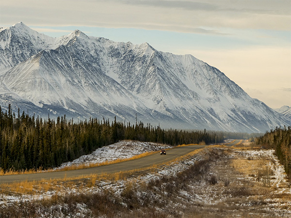
The tallest mountains in Canada can be found in Kluane National Park and Reserve.
Gyeongju National Park, South Korea
Regardless of the season, the trails that loop around Gyeongju National Park in South Korea invite you to go on a journey. Gyeongju is the country’s only historical national park, and features in Lonely Planet’s inspired book Best in Travel 2022 for its open-air palaces and grassy tombs of the Silla nobility which Lonely Planet writer Phillip Tang describes as ‘a museum without walls’. Expect terraced temple sites, pleasure gardens, fortress ruins and more in the national park where you can appreciate rock carvings, pagodas and ancient artefacts in situ. New train links make the park even easier to visit.
Fun fact
Korean Tourism Organization recently released a Youtube clip of KPOP stars gambolling in and around Gyeongju National Park.
Location
Gyeongju National Park is located in the province of Gyeongsangbuk-do, South Korea. It was first designated as a national park in 1968 and is divided into eight districts over a total area of 137,00 hectares.
Things to do
The city of Gyeongju was the capital of the Silla kingdom from 57BC to 935AD and relics of the dynasty are dotted around the national park. Sign up for a hiking tour that will lead you to 1000-year-old temples, statues, and stunning Buddhist relics.
Brush up on your ancient history with a visit to the Gyeongju National Museum, which has a collection of 30,000 archaeological artefacts and artworks, take a tour of the Bulguksa Temple, which dates back to the eight century and sit in the calm at the Dabotap and Seokgatap pagodas near Daeungjeon, the main hall.
Hiking Mt Nasam is a great way to burn off the Hwangnam bread you had for lunch. The small pastry with a filling of red bean paste is surprisingly filling and can be found at the Hwangnam Bbang bakery near Daereungwon Tomb Complex. While in the area, the traditional folk village of Yangdong is also worth a visit.
Highlight
Many of the Silla sites are located in Gyeongju National Park. However, the vibrant tumuli (ancient burial mound) are mainly concentrated in the Daereungwon tumuli complex of royal tombs, which roll across the verdant manicured landscape.
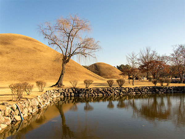
Gyeongju is the country’s only historical national park.
Judbarra/Gregory National Park, Northern Territory
You’ve heard of Kakadu. What about Judbarra, the second largest national park in the Northern Territory? Stand in the valley and listen. You’re bound to hear a chorus of insects, whirring in the wind. Look up and you’ll see the rugged, weathered shoulders of the ridges that rise from the valley floor. Or, if you’d prefer a lofty view, head off along the Escarpment Walk which commands views of the Victoria River and bony limestone formations.
Fun fact
The park is crisscrossed with walking tracks, which are popular with binocular-toting bird-watchers keen to spot the Gouldian finch, yellow-rumped mannikin and white-quilled rock pigeon.
Location
Judbarra covers an area of about 13,000 square kilometres and features a spectacular range and sites of great cultural significance to the Ngarinyman, Karrangpurru, Nungali, Malngin, Wardaman, Ngaliwurru and Bilinara First Nations people, who are the traditional owners and joint managers of this land.
Things to do
Gregory’s Tree stands like a monument to Australian explorer Augustus Charles Gregory whose boat was wrecked at the nearby site of Timber Creek after sailing up the estuary of the Victoria River. The early pioneer carved the date 2 July 1856 into the bulbous boab in an area that also has cultural significance to First Nations people.
Fishing is a popular activity in Judbarra/Gregory National Park. Keen anglers are being lured to the new Lupayi campground, 47 kilometres from the Victoria Highway, at the start of Jasper Gorge as it is accessible for 2WD vehicles and caravans in the dry season (May to October), and 4WD vehicles year-round. Please remember: the NT is saltwater crocodile territory, too.
Highlight
The Nawulbinbin Walk traces the escarpment past galleries of rock art that Parks & Wildlife NT are trying to protect and preserve. Access is via the Joe Creek picnic area.
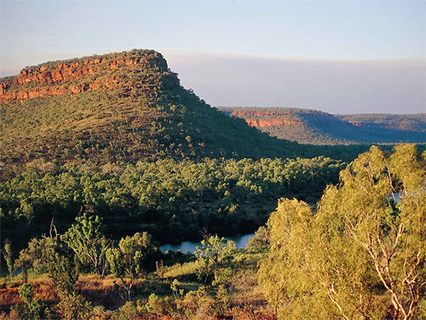
Welcome to the second largest national park in the Northern Territory.
Mesa Verde National Park, Southwest Colorado
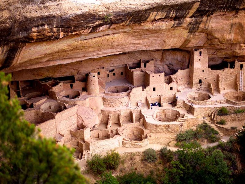
Mesa Verde is Spanish for ‘green table’ and was so named after Spanish explorers first saw the wild landscape blanketed in green. Immerse yourself in the landscape in autumn and you will see it painted in golden hues; in spring and summer, the wildflowers turn their faces to the sun; in winter, you can access the bowl-of-ice-cream backcountry on cross country skis.
Location
Mesa Verde National park is located in Montezuma County, and is close to the towns of Mancos and Cortez. It has more than 5000 sites scattered over the 21,240-hectare park, making it the largest archaeological preserve in the US.
Fun fact
The Ancestral Pueblo people were keen observers of the sky and Mesa Verde’s certification as the world’s 100th International Dark Sky Park in 2021 recognises the quality of its star-filled skies. Enjoy a ranger-led stargazing tour from Morefield Campground or Far View Lodge, the only lodging inside the national park.
Things to do
Embark on the groomed Cliff Palace Loop trail, which has several vantage points from which to view the cliff-dwellings that form part of the area listed as a UNESCO World Heritage Site in 1978.
Start dreaming about your Colorado adventure by downloading an audio tour of the Mesa Top Loop Drive to get A Pueblo Perspective on Mesa Verde, which will transport you back to 600 AD, when the caves in the flat-topped cliffs first became home to the Ancestral Pueblo people. The 700 years tour also offers visitors a window into the culture and lifestyle of the Puebloan Peoples.
Highlight
There’s just one hiking trail that meanders around Mesa Verde National Park and offers views of the prehistoric rock carvings. Follow the Petroglyph Point Trail to Point Lookout, the iconic geological formation that resembles a pair of false teeth left on a bedside table. The trail starts near the Chapin Mesa Archaeological Museum, which is also a must, and skims along the side of a cliff, past the petroglyphs and up a staircase of sorts to the top of the mesa.
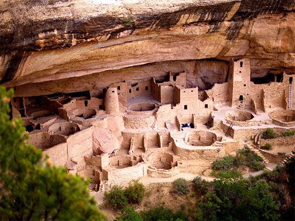
For over 700 years, the Ancestral Pueblo people built thriving communities on the mesas and in the cliffs of Mesa Verde.
Cairngorms National Park, Scotland
When people think of national parks in the UK they think of the Lake District. But what about Cairngorms National Park, home to the UK’s highest mountain range? Gazing across the landscape feels like falling into a childhood fairy tale: with the scenic SnowRoads route nudging you along a track that veers from villages to castles with highland views. The route, which loops through the largest of Britain’s national parks, is home to high plateaux with the rarest of habitats where you will see red squirrels darting around and reindeers roaming free.
Fun fact: Cairngorms National Park is the only park in Britain to have a free-ranging herd of resident reindeers.
Location
The national park, at 4528 square kilometres, covers six per cent of Scotland and is located between the cities of Perth and Inverness.
Things to do
You take the high road and I’ll take the snow road: pull in at three stunning scenic route photo-post installations along the way to capture changes in the landscape as part of a citizen science initiative designed to provide a visual record about the changing landscape.
The difference with national parks in the UK is that people can live and work within the national parks. So in addition to the rugged crags, wildlife and lovely lochs, you’ll find ancient fortresses, distilleries and museums along with a range of other attractions.
You can also admire stunning architecture, from bothies to castles, visit places of interest such as a working distillery, Corgaff Castle, and Scotland’s highest golf course. And engage in a spot of wild swimming near the Glas Allt Waterfall.
Highlight
Take your time exploring the SnowRoads as this is one of the best breeding areas for birds in the north east of Scotland.
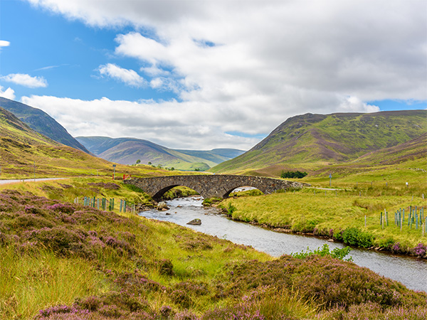
Fall into a fairytale at Cairngorms National Park.
Keibul Lamjao National Park, Manipur, India
This lesser-known national park in India is a haven for at-risk wildlife species such as the endangered brow-antlered deer (sangai deer) which you have a slim chance of encountering when you undertake a guided tour. Keibul Lamjao National Park is the world’s only floating sanctuary, located as it is on the southern part of Loktak Lake, the largest freshwater lake in eastern India and largely comprising floating biomass swamp islands known locally as phumdi. The rugged park and phumdis are great for birdwatching: spot raptors like the black eagle and shaheen falcons and hornbills, too. The park is home to a small population of hog deers.
Fun fact
Phumdi is a heterogeneous hillock of soil vegetation and organic matter at various stages of decomposition which occupy almost half of the lake area and three quarters of the Keibul Lamjao National Park area. Expect fruity aromas.
Location
Keibul Lamjao National Park was declared a national park in order to protect the population of sangais, which are in danger of losing their habitat. The world’s only floating national park (located in the north-eastern part of India) stretches over 2,200 hectares and provides livelihood for as many as 4000 fishermen and their families from the First Nations people, who live along its banks in small hand-crafted huts.
Things to do
Take a small boat ride into the phumdis to see the biomasses floating around the national park. The rugged park and phumdis are also great for birdwatching: spot raptors like the black eagle and shaheen falcons and hornbills, too.
The phumdis are strong enough for animals and humans to walk on, which you should do in your quest to spot the lake’s small population of sangai deers, one of the rarest animal species in the world. The floating sanctuary is also home to a small population of hog deers.
Local families rely on the freshwater lake for their livelihoods, and the cultivation of rice is common. Visit the Women’s Initiative for Sangai Conservation which has a small shop just outside the gates of the national park.
Highlight
Your contributions to Keibul Lamjao National Park help to conserve the area, which is crucial to the cultural heritage of the Thang, Brel and Maril tribes, and the sangai deer, which is the state animal of Manipur and remains at risk.
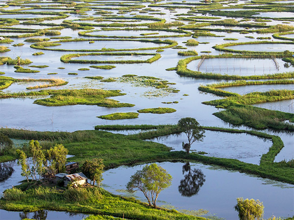
Welcome to the world’s only floating national park.
Reisa National Park, Norway
The Human Development Index has ranked Norway as the best place to live on Earth several years in a row. Apart from leading the world when it comes to sustainable standards, the country is blessed with natural beauty, which Norwegians take full advantage of while visiting Reisa National Park.
Fun fact
The waterfalls in Reisa National Park freeze in winter and you can experience this Instagram-worthy sight by skiing along the Reisa River.
Location
Reisa National Park is located in the Lyngenfjord region in Troms, northern Norway. The mighty 80,600 hectare park stretches from the mountain plateau landscape through untouched valleys into a more alpine landscape.
Things to do
The dreamy landscape is virtually untouched and comprises canyons, rivers teeming with salmon, wetlands and turquoise tributaries that run like ribbons through the valleys. The Reisa National Park is also defined by its mountains and plateaux and it’s where you will find Lake Blåisvatnet (the Blue Lake), which stands in stark contrast to the backdrop of spiky mountain summits.
You can join a local guide for a fun tour with Alaskan huskies, take the family-friendly Lulledalen forest path, and enjoy the bucolic experience of picking blueberries along the path to Sarafossen waterfall.
You can also admire Stone Age rock art in Sieimma, which has been accessible to the public since 2013. Predators such as wolves and lynxes are common sights in the area, while sightings of wolves, bears and polar foxes are less common.
Highlight
Fans of the Wim Hof method will appreciate the benefits of an icy cold dip in Lake Blåisvatnet.
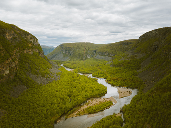
Norwegians take full advantage of natural beauty at Reisa National Park.





LEAVE YOUR COMMENT