Dust off your boots and head to Ivvavik National Park
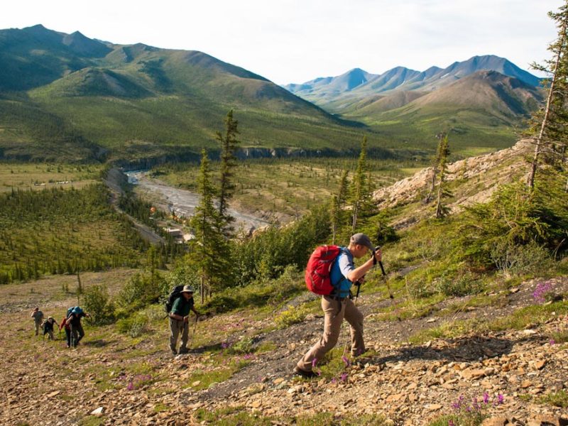
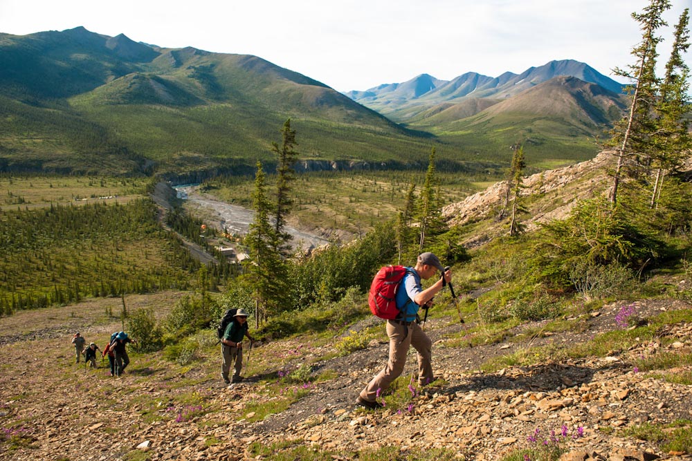
It's a bumpy ride to get to Sheep Creek Base Camp in Ivvavik National Park in Canada (photo: Birgit-Cathrin Duval).
Under the midnight sun, the lunar landscapes of Yukon’s Ivvavik National Park offer views like no other place in the world…
Words by Birgit-Cathrin Duval.
“Hold on, it’s going to be a rough landing,” Mike calls out to the passengers. Strong winds toss the tiny Twin Otter back and forth like a rubber ball while the pilot steers toward the runway marked with oil barrels.
There is a bang like a burst tyre, and fist-sized rocks fly in every direction.
Mike brakes sharply and grins: “Welcome to Sheep Creek International Airport.”
Ivvavik National Park is on the northern border of the Yukon Territory in Canada.
It can only be reached by twin-engine bush plane from Inuvik in the Northwest Territories.
This is the very northern edges of Canada’s west on the shore of the Arctic Ocean’s Beaufort Sea; next stop is the North Pole region.
If you know your Canadian geography, Ivvavik is 560 kilometres north of Dawson City, and 2300 vast kilometres north of Vancouver. It is closer to the eastern edge of Russia than Vancouver.
Fewer visitors see this prehistoric landscape each year than scale Mount Everest; if there truly is an edge of the world, then Ivvavik might very well be it.
Though every crater and cranny on the moon has a name, the mountains in Ivvavik are nameless, with a few exceptions that are the life work of Mervin Joe, one of a handful local park rangers and cultural resource managers.
Mervin Joe has named a handful of peaks in the region, with some of his favourites called ‘Halfway to Heaven’, ‘Dragon’s Gate’, and ‘Inspiration Point’.
It’s clear he has a fair bit of time on his hands up here but actually, during June and July, life and light just don’t stop.
Chef Louisa Kalinek is grinning from ear to ear because of the eggs that were unharmed during the rough landing.
Finally, she can replenish her cooking supplies. While the pilot unloads food and luggage, Mervin Joe keeps an eye on his surroundings – just a few hours ago, a grizzly bear had padded down the gravel road.
As the gate closes behind the group, the ranger informs us the camp is, thankfully, protected by an electric fence.
The kitchen, solar-powered showers, and two toilets are the only luxuries, and the remaining vestige of civilisation disappears behind the mountains with the departure of the Twin Otter.
While Mervin Joe and his colleague Rachel Hansen explain the use of bear spray and the emergency telephone as part of their safety instructions, it becomes apparent to me that, out here, we are pretty much on our own.
In Sheep Creek Camp, I lose track of time. The sun never sets during the Arctic summer, so it is as bright outside at 3 am as it is at noon.
Because sudden weather changes with temperatures of up to -15°C are not uncommon in summer, thermal clothing and down-filled sleeping bags are essential luggage.
Yet the midnight sun beats down on the tent; it is positively sauna-like inside and I find myself sweating at temperatures of more than 30°C in the Arctic.
The only thing that can cool me off is a dip in the ice-cold water of Sheep Creek.
On the longest day of the year, Mervin Joe leads us on the climb up Inspiration Point.
Once we have our ascent from the valley behind us, my jaw drops: the midnight sun bathes the bare, conical mountain peaks in a shimmering gold light.
At midnight, we stand on the plateau of Inspiration Point and understand why Mervin gave this place its name.
The sheer, endless valley from which Firth River flows forth like a turquoise ribbon glitters a velvety green.
This light and landscape are like nothing else in the world, overwhelming us with the sheer spectrum of colour and breadth.
If vegetation were to grow on the moon, it would look like Ivvavik.
The surroundings look prehistoric. I wouldn’t have been surprised if a T-Rex were to suddenly walk across the tundra.
During the Ice Age, there were no glaciers in this part of the Yukon, so nature created a unique landscape.
The Inuvialuit called this area ‘Ivvavik – place of birth’ because of the porcupine caribou herds that raised their young in the valleys here.
They are responsible for this area being named a national park in 1984.
This enabled a land agreement between indigenous people and the Canadian government which guarantees that this 9750-square-kilometre park will remain untouched, particularly by the oil companies.
Today, Ivvavik is something of a crown jewel of the Canadian national parks, and no park is more remote, wild, or untouched.
Renie Aray has been fighting for this for years. The 71-year-old campaigned to establish the national parks. Today she is the cultural advisor of the employee base of Sheep Creek Camp and is sharing her extensive knowledge of the land and people with us.
In addition, she heals Jenny, who seemed to have sunstroke, with a homemade remedy made from boiled pine resin. Chef Louisa swears by it.
She claims the remedy cured her breast cancer. The pure air and the clear mountain water helped, as well.
The days are filled with fishing in the Firth River (a licence must be requested in Inuvik in advance) and hiking.
While exploring along the Firth River, Rachel leads us to the old ore deposits known to her people. She is proud to be Inuvialuit and maintains the traditions of her forefathers by “living off the land” – we hear this from her time and time again.
This also includes hunting. She spends her summer in various camps in the northern national parks, and loves her career as a ranger. Being paid to roam through the wilderness? Simply priceless, beams the 31-year-old.
In the evenings, we enjoy a sumptuous meal, but nobody is tired, and it doesn’t grow dark.
Louisa prepares traditional dishes – dried fish, caribou meat, fried bread – while Renie tells stories about fighting for the national parks in the 1980s and going to Ottawa with her petition.
After a brief (and bright) night, we find ourselves in the small kitchen, half-asleep. Today, Mervin Joe is leading the group on a hike to Halfway to Heaven.
There are no markers, so Mervin Joe always has to re-orient himself using prominent features, and the climb really does feel as if we were on our way to heaven.
Grassy hills are interspersed with stony trails; a rugged ridge looks like a dragon.
“That’s the Dragon’s Gate,” explains Joe, and tells us how our destination earned its name: when he received a radio transmission from Sheep Creek Camp asking where he was, Joe responded “Halfway to Heaven.”
As the wind drops, black flies and mosquitoes swarm the hikers. Untouched beauty has its price.
Mosquito spray and jackets help keep the biting and stinging insects at bay, while we regain our strength with a lunch of sandwiches on what is now known as ‘Lunch Rock’ – looks like we’ve just made history.
From here onward, the path is clear: the peak of Halfway to Heaven rises toward the sky like the jagged spine of a dragon.
For the group, Heaven is impossibly distant, even if we’re only travelling halfway there.
The ascent to the ridge is high-alpine, and the sky seems close enough to touch.
I may have crawled the last few metres to the sky window, a sort of crenelated projection in the weathered cliff, to take my photo of the peak. Mervin Joe informs the base camp that our group has reached Halfway to Heaven and my body floods with endorphins.
Heaven? I feel like I may be there already.
Ivavvik National Park travel information
Parks Canada organises five-day guided tours in Ivvavik National Park in June and July, including the flight from Inuvik to Sheep Creek, meals, camping equipment, and national park fees.
Arrival: You can get to Inuvik from Whitehorse with a rental car or RV via Dempster Highway (Northwest Territories) or with Air North via Dawson City, Old Crow toward Inuvik.
Ivvavik National Park is generally accessible by air only, and several charter companies serve the area.

LEAVE YOUR COMMENT